LCRT Lowcountry Rapid Transit
Welcome!
Lowcountry Rapid Transit Virtual Public Meeting June 10 - July 10, 2020
Thanks for your interest in South Carolina’s first high-capacity transit system – Lowcountry Rapid Transit! We value your feedback as we push forward with Phase 2 of project development, but we also value your health and safety. That’s why, in accordance with ongoing guidelines in the wake of the COVID-19 pandemic, the project team has elected to host a virtual public meeting to help keep our Lowcountry neighbors healthy. This meeting will feature all of the same materials that would have been available at an in-person meeting, but is available 24/7 now through July 10.
Project Overview
Lowcountry Rapid Transit (LCRT) is a bus rapid transit system that will travel the “spine” of the Lowcountry, along US 78 and US 52 (Rivers Avenue). A comprehensive study conducted by the Berkeley-Charleston-Dorchester Council of Governments (BCDCOG) identified bus rapid transit as the best solution to improve mobility in our region.
LCRT is more than just a bus rapid transit system; the project will transform the infrastructure in our region to improve mobility for people on public transportation, in cars, on foot and on bikes. This system will connect the communities of Charleston, North Charleston and Summerville and will be a catalyst for economic growth and prosperity throughout the area.
New to Bus Rapid Transit?
You can also view our BRT 101 video on the project website by clicking the link below.
View the Video
Recent Progress
We’ve made exciting progress on the project since our last public meeting in June 2019. Some highlights include:
Completed Phase 1 and entered into the FTA’s Project Development phase of the Capital Investment Grant program.
Completed the refinement of the LCRT alignment.
Began the Transit Oriented Development study.
Performed an on-board survey for the origin and destination study. You may have seen us on the bus; thanks for the feedback!
Defined proposed roadway treatments for the LCRT.
Project Timeline
The project timeline below is estimated under the New Starts Capital Investment Grant program guidelines. Select the dots below for specific milestones within each phase.
2014 - 2016 Local Planning
- Pre-Project Development
- Comprehensive Operational Analysis
- Alternatives Analysis
- FTA Guidelines/Travel Demand Forecasting
- Public Engagement
2016 - 2019 Project Programming
- Bus Rapid Transit Preferred Alternative Identified
- 2016 Half-cent sales tax referendum passed in Charleston County
- Agency Coordination
- Informal Scoping & NEPA Checklist
- Identify Funding & Schedule LRTP
- Existing Conditions Evaluation & Conceptual Design (10%)
- NEPA Class of Action & Initiate NEPA Scoping*
- Request Entry into Project Development*
2019 - 2023 Capital Investment Grant Program
- Project Development
We are here
- Complete NEPA
- Adopt a Locally Preferred Alternative
- Complete 30% Design
- Must Receive Medium Rating for Project Justification & Financial Commitment Criteria*
- Engineering
- Significant Progress with Engineering
- Recommended for Construction Grant Agreement
2023 - 2026 Construction
- Construction Begins
- Project Completion
Choose A Meeting Section
Click on one of the tiles below to explore that topic. You may also navigate through the meeting using the tabs at the top of the page.
Route Alternatives Transit Oriented Development Interactive Map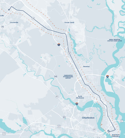
Route Alternatives
Phase 1 of the project kicked off in 2019. The project team identified 16 alignments that went through a fatal flaw analysis to evaluate which alignment would work from an operational standpoint. After gathering input from the public and stakeholders and evaluating the results of the fatal flaw analysis, 12 reasonable alternatives were identified. These were carried into Phase 2, which started in early 2020, and were further evaluated with measures based on the project purpose and need. The measures included:
- Traffic operations
- Bicycle and pedestrian mobility
- Environmental impacts
- New and existing development
- Transit connections and integration
- Reliability and travel times
- Population and employment
- Ridership potential
- Public and stakeholder input
The Recommended Alternative
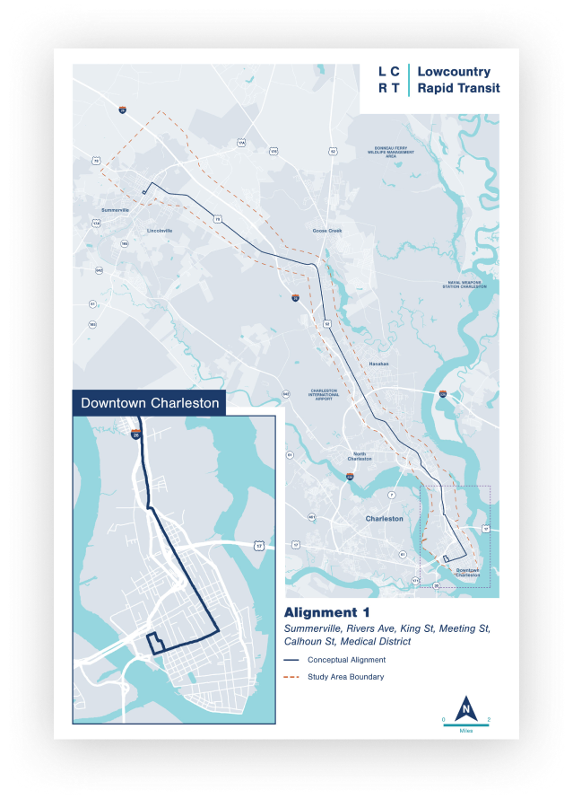
Alternative 1 has been identified as the recommended alternative for LCRT. Alternative 1 connects downtown Summerville along US 78 with North Charleston along Rivers Avenue and King Street Extension and into Charleston by way of Meeting Street and Calhoun Street, looping through the Medical District.
Capital Investment Grants Program
Our goal is to refine Alternative 1 to best fit the needs of the local community and stakeholders, especially considering connectivity and accessibility.
LCRT is partially funded through the Charleston County Sales Tax program. The project will be applying for additional funding through the Federal Transit Administration’s Capital Investment Grants program. This program is competitive; at a minimum, it requires that the project meet a set of criteria that fall into the following categories:
- Cost effectiveness
- Mobility improvements
- Congestion relief
- Land use
- Economic development
- Environmental benefits
Alternatives Evaluation Process
The goal of the alternatives refinement process is to:
-
1.
Identify a recommended alternative to advance through the National Environmental Policy Act (NEPA) process for environment review and clearance.
-
2.
Complete design to refine the alternative into a competitive Federal Transit Administration (FTA) Capital Investment Grants project.
Project Purpose & Need
The criteria described on the previous tab were established based on the project’s purpose and need, goals and objectives, FTA criteria and industry standards of bus rapid transit. Click through the tabs below to learn more about the project’s purpose and need.
Improve mobility and connectivity of the transit system and region.
Enhance bus running time/speeds and reliability
- Dedicated right-of-way
- Number of railroad crossings
- Travel times
- Distance between stations
Improve mobility and access to all communities
- Serve ridership generators
- Integration with existing transit services
Connect communities and residential areas with employment and activity centers
- Transit dependent
- Environmental justice
- Cultural resources
- Section 4(f) properties
Promote a cost effective and accessible transit alternative.
Create a safe, multi-modal transportation system with travel choices
- Connect to bike infrastructure
- Connect to pedestrian facilities
Develop a viable plan outlining costs and steps for transit implementation
- BRT constructability
- Operating expense per trip
- Capital costs per rider
Support land use and transit objectives in the region.
Support economic development plans along the corridor with access to employment opportunities, transit centers and key destinations
- Serve existing population
- Serve existing employment
- Potential ridership
- On-street parking
Promote livable communities through transit-oriented development
- Ability to support existing and generate new development
Reasonable Alternatives
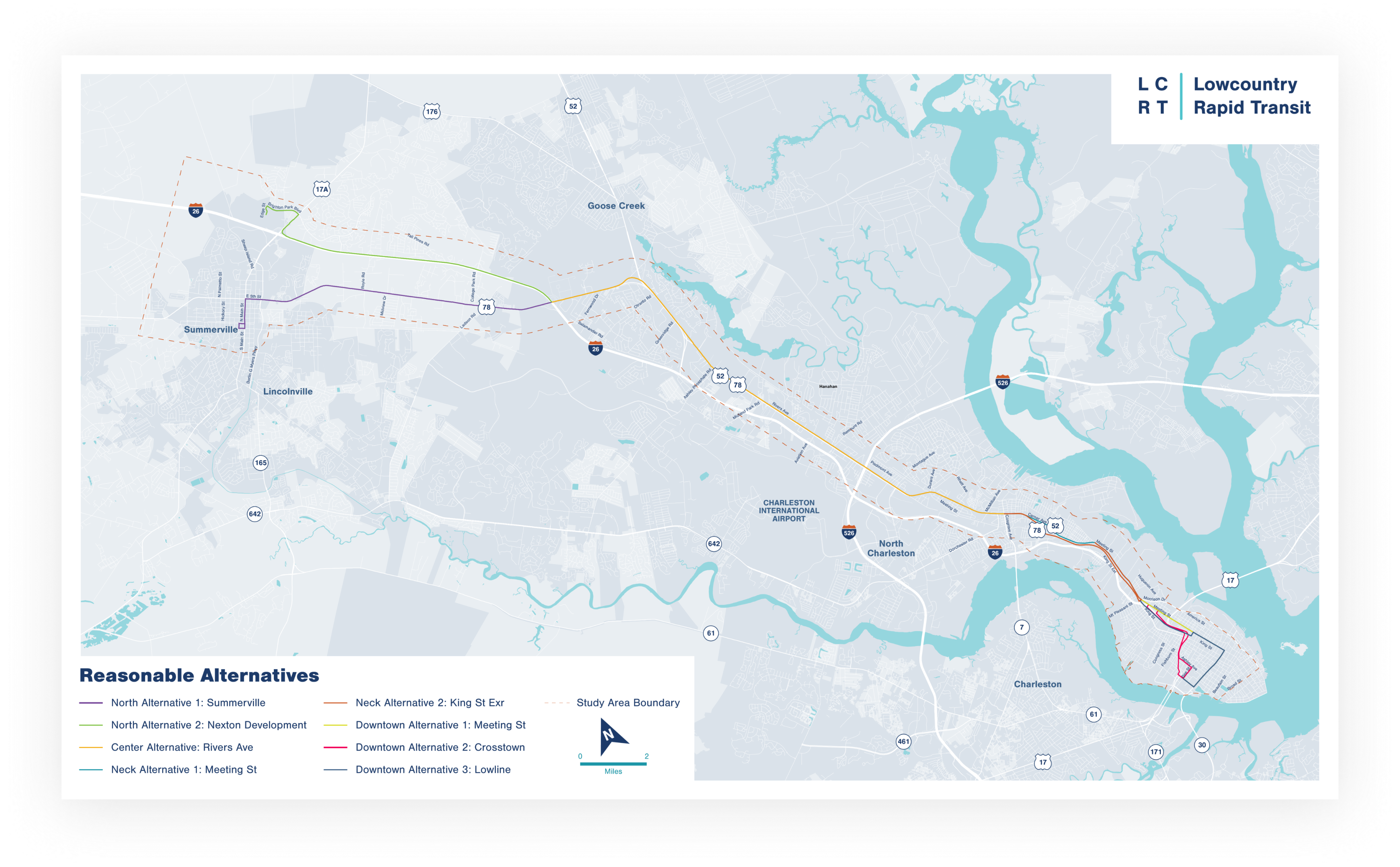
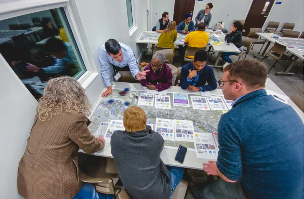
The image below shows the 12 reasonable alternatives, which were evaluated against a range of measures, each with different weights. Click on the image below to view the full-sized map.
Evaluation Scoring
Combined, the measures above help us determine which segments of the project corridor sufficiently meet the FTA’s criteria and which would pose challenges if implemented. For example, the alternatives that included Summerville scored higher than those that included Nexton. All alternatives that included the Crosstown received comparatively lower scores.
Alternative Ranking
The following ranking of alternatives was the result of the evaluation.
| Rank | Alternative |
|---|---|
| 1 | High Rank Alternative 1 - Summerville, Rivers Avenue, King Street, Meeting/Calhoun |
| 2 | High Rank Alternative 3 - Summerville, Rivers Avenue, King Street, Lowline |
| 3 | High Rank Alternative 4 - Summerville, Rivers Avenue, Meeting Street, Meeting/Calhoun |
| 4 | High Rank Alternative 6 - Summerville, Rivers Avenue, Meeting Street, Lowline |
| 5 | Medium Rank Alternative 10 - Nexton, Rivers Avenue, Meeting Street, Meeting/Calhoun |
| 6 | Medium Rank Alternative 7 - Nexton, Rivers Avenue, King Street, Meeting/Calhoun |
| 7 | Medium Rank Alternative 9 - Nexton, Rivers Avenue, King Street, Lowline |
| 8 | Medium Rank Alternative 12 - Nexton, Rivers Avenue, Meeting Street, Lowline |
| 9 | Low Rank Alternative 2 - Summerville, Rivers Avenue, King Street, Crosstown |
| 10 | Low Rank Alternative 5 - Summerville, Rivers Avenue, Meeting Street, Crosstown |
| 11 | Low Rank Alternative 8 - Nexton, Rivers Avenue, King Street, Crosstown |
| 12 | Low Rank Alternative 11 - Nexton, Rivers Avenue, Meeting Street, Crosstown |
The Recommended Alternative
The recommended route for LCRT is Alternative 1. This route travels from Summerville along US 78 to North Charleston, along US 52/Rivers Avenue to King Street Extension, and into downtown Charleston on Meeting Street and Calhoun Street to the Medical District. This alternative may change or be further refined based on the need for it to be competitive in the FTA federal funding program. This alternative outranks other alternatives because it:
- Has the highest annual ridership
- Minimizes railroad crossings
- Offers a competitive cost per rider
- Connects to the highest number of employment areas
- Requires lower operating expenses
Transit Roadway Design Elements
The project team evaluated the corridor to see how LCRT would best fit the existing roadway.
There are two options for this corridor:
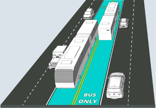
Dedicated Bus Lanes
In areas of wide-roadways with large medians (such as Rivers Avenue), LCRT can operate in separate, dedicated lanes. These lanes would be added in the existing medians and would not decrease the number of travel lanes for other commuters.
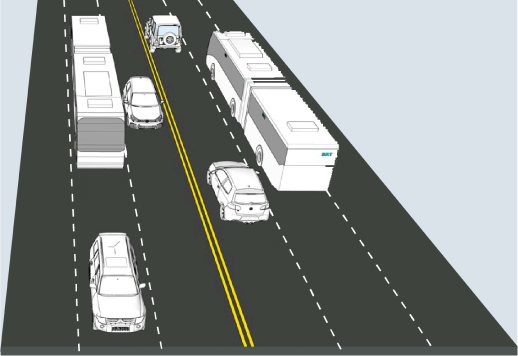
Mixed Traffic
In more confined areas of two lane streets with minimal medians (such as US 78 as well as Downtown), LCRT can operate in mixed traffic aided by signal prioritization.
What's Next
Click on one of the tiles below to explore that topic. You may also navigate through the meeting using the tabs at the top of the page.
Transit Oriented Development Interactive MapTransit Oriented Development
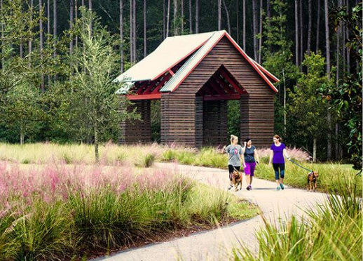
What does Transit Oriented Development look like?
With our region seeing steady growth, an important aspect of LCRT is to consider the location of station areas and the thoughtful preservation and development of the communities that surround them. Click on the yellow dots below to learn more about the components of Transit Oriented Development (TOD).
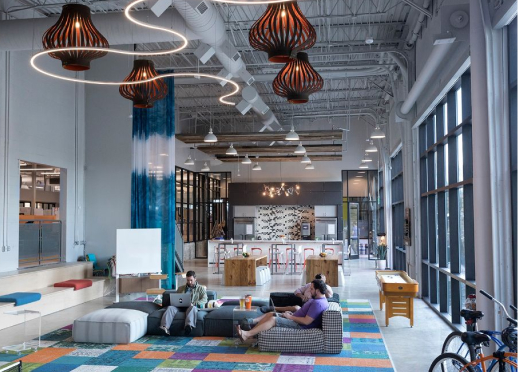
Quality public transportation incorporates transit services that are reliable, safe, affordable and competitive with other modes of transportation.
Pedestrian and bicycle connectivity means providing direct, safe and convenient infrastructure to make walking and biking real options for people to access daily destinations.
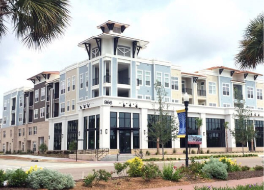
Mixed use development incorporates a blend of land uses (i.e. housing, jobs, social venues, shopping, etc.) within a specific area or within a single development.
Most transit trips start as a walking trip.
People walking around station areas with strong TOD would find:
- A well-connected, complete street grid short blocks, ample sidewalks, bike paths, slow traffic
- Development density within 1/4 to 1/2 mile around the transit station
- Pedestrian-oriented building entrances and other site design elements
- A strong mix of uses at different price points with housing options and different building types to support shopping, working, living
- Efficient parking carefully allocated within the station area
- Strong place making elements that reflect the culture, character and natural features of the existing neighborhood
What is the goal of the TOD study?
- A vision for equitable development that supports livability around each of the proposed LCRT stations
- A realistic growth strategy for preservation and development
- A policy tool-kit that will enable local decision-makers to proactively guide and plan for future growth and needs
Station Area Refinement
Through a series of workshops and other stakeholder involvement, we’ve identified potential station areas along the project corridor. As the project progresses, we will continue to refine the station areas to determine which ones:
- Offer the most connectivity to existing services and employment centers
- Will provide the most benefit to existing and new communities
Place Types
We asked the public to think about TOD station areas in terms of “place types” that reflect the local community’s goals and could evolve over time. Available place types included:
-
Neighborhood
Future neighborhood station areas will encourage infill and redevelopment to support mostly residential uses as well as schools, religious gathering places, civic spaces and neighborhood-scale businesses. -
Town Center
Future Town Center station areas will encourage infill and redevelopment to support an equal balance of jobs and housing with characteristics like traditional “Main Street” areas. These are centers of commercial and civic activity with shops, restaurants, local businesses, civic and public institutions. -
Employment Hub
The future Employment Hub station areas are those locations where there will be an emphasis on clustering of jobs. This primarily means traditional office buildings, or warehouse and light industrial uses that reflect a more urban development pattern. -
Downtown Neighborhood
Downtown Neighborhood station areas will be residential in character with a mix of housing including high density single family, townhomes and multi-family apartments and condos. There will be an emphasis on encouraging nearby neighborhood amenities including shopping, restaurants, civic spaces and parks and some local businesses and other employment-based uses. -
Downtown Employment Hub
The Downtown Employment Hub station areas will predominantly include office, institutional, healthcare, retail, and hospitality-based uses with a high concentration of jobs. Some high density residential will also be located nearby.

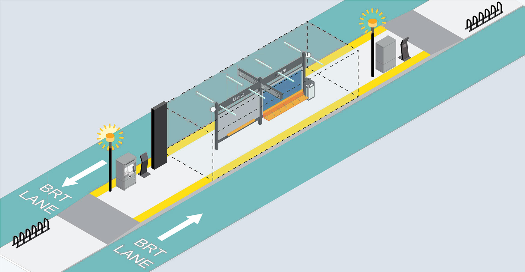
Station Features
One of the project's next steps will be to develop architecture and branding designs for stations along the LCRT route. Below is a general overview of the key elements that will be built into each station. Hover on the dots on the image below to reveal specific information about each station feature.
- Area Lighting
- Ticket Vending
- Accessibility Considerations
- WiFi
- Station Identification
- Ticket Validation
- Shelter
- Shelter Lighting
- Security Elements
- Information Panel
- Real-Time Information Display
- Seating
- Advertising Panel
- Waste & Recycling Receptacles
- Level-boarding
- Bicycle Parking
What's Next
You’ve reached the end of the Transit Oriented Development section. Click on one of the tiles below to explore another topic or leave a comment. You may also navigate through the meeting using the tabs at the top of the page.
Route Alternatives Interactive MapRecommended Alternative
Welcome to the interactive map.
Select the highlighted segments to learn about the recommended alternative. Use the tabs above the map to learn about different aspects of the project. Click the button below to start exploring the interactive map.
Click on the colored route segments to learn more about the opportunities and roadway designs of each portion of the corridor.
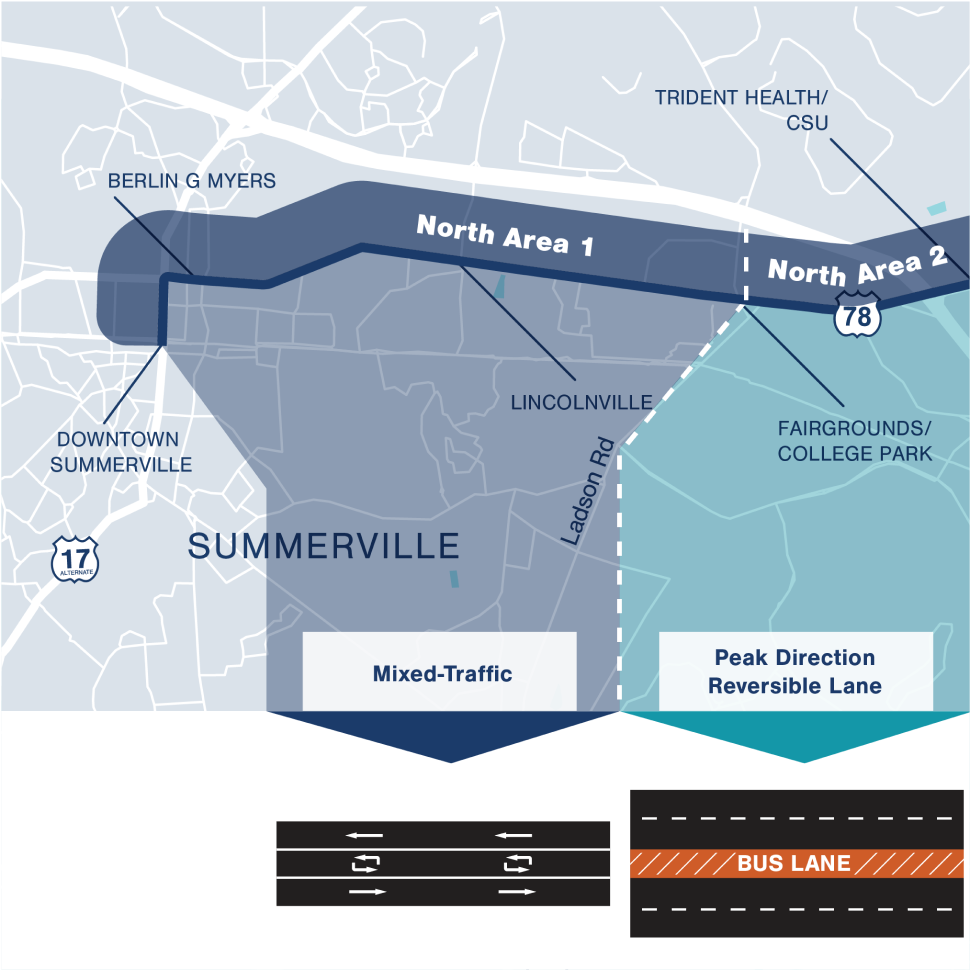
Summerville/US 78
Corridor Opportunities
Serves established areas
Opportunities for expansion & improvement
Park-and-ride opportunities
Serves transit-dependent communities
Higher ridership than Nexton alternative
Roadway Design
The Summerville/US 78 area of the recommended alternative includes two roadway designs, which would operate in mixed-traffic and peak direction reversible lanes.
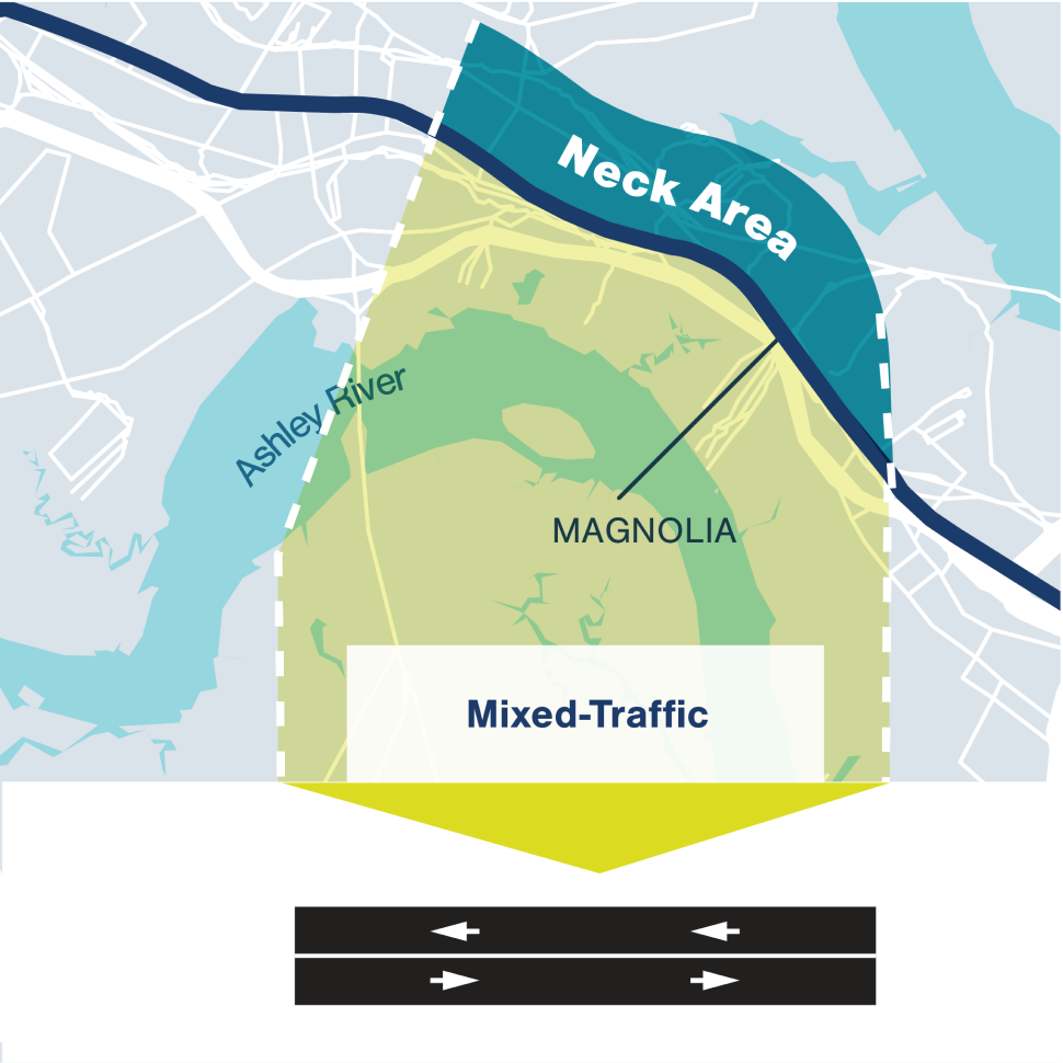
King Street Extension
Corridor Opportunities
One at-grade railroad crossing
Reasonable capital costs
Low impact to project schedule and NEPA
Local community support
Connects transit-dependent communities
Future grants/funding can improve user mobility
Roadway Design
The image below shows the roadway design proposed for the Neck Area of the recommended alternative, which would operate in mixed-traffic.
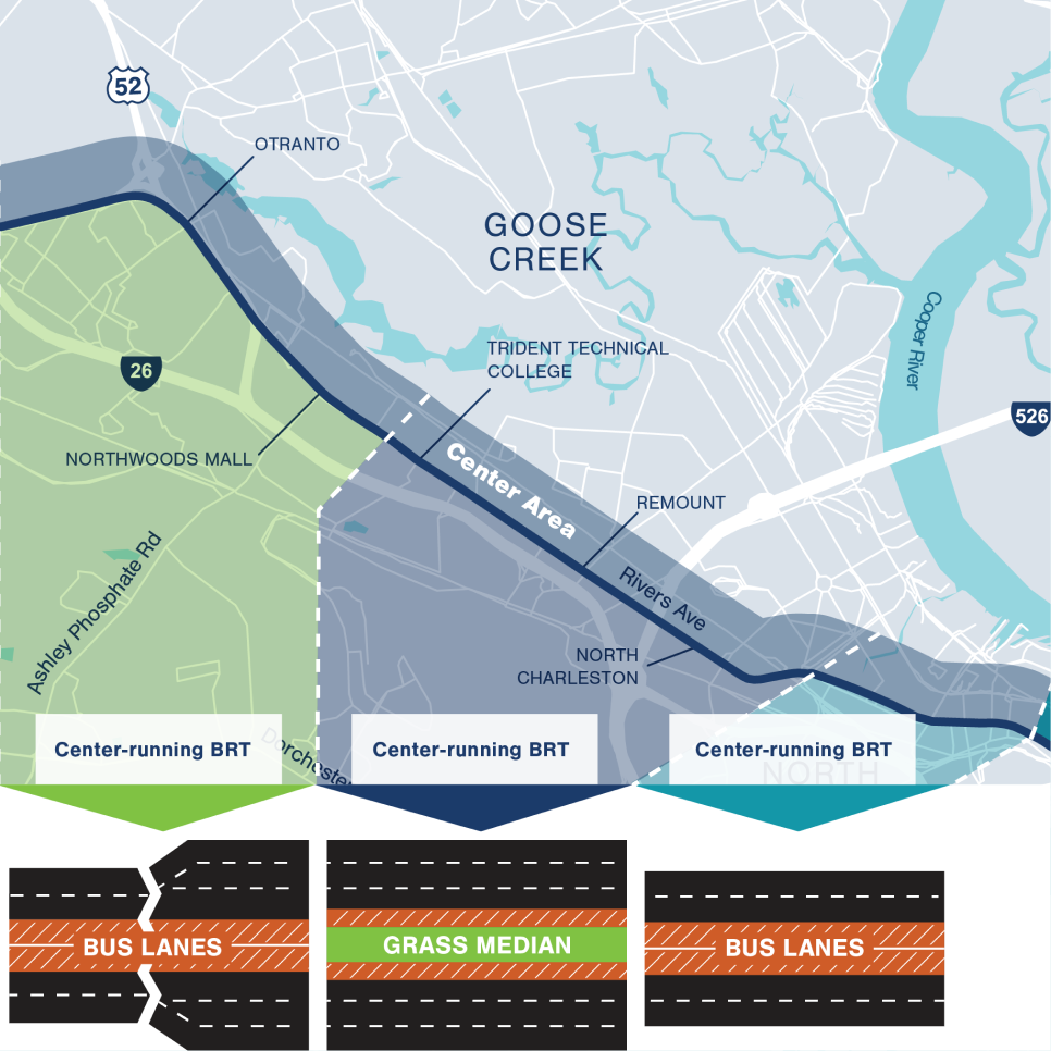
US 78/US 52 (Rivers Avenue)
Corridor Opportunities
Ample right-of-way
Established transit service
Center-running, dedicated BRT lanes
Mix of businesses and residences
Redevelopment potential
BRT enhancements would add to the corridor's safety
Bicycle and pedestrian connectivity
Improvements to un-signalized lefts and u-turns
Roadway Design
The Rivers Avenue area of the recommended alternative includes three different roadway designs, which would operate in center-running BRT lanes.
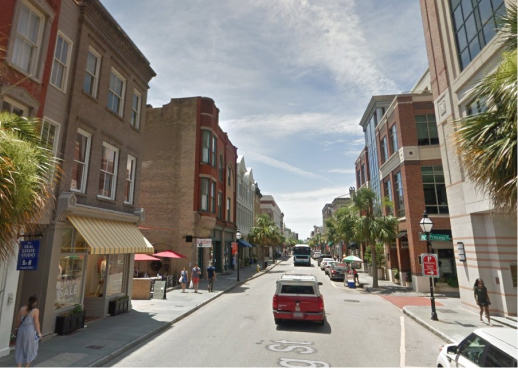
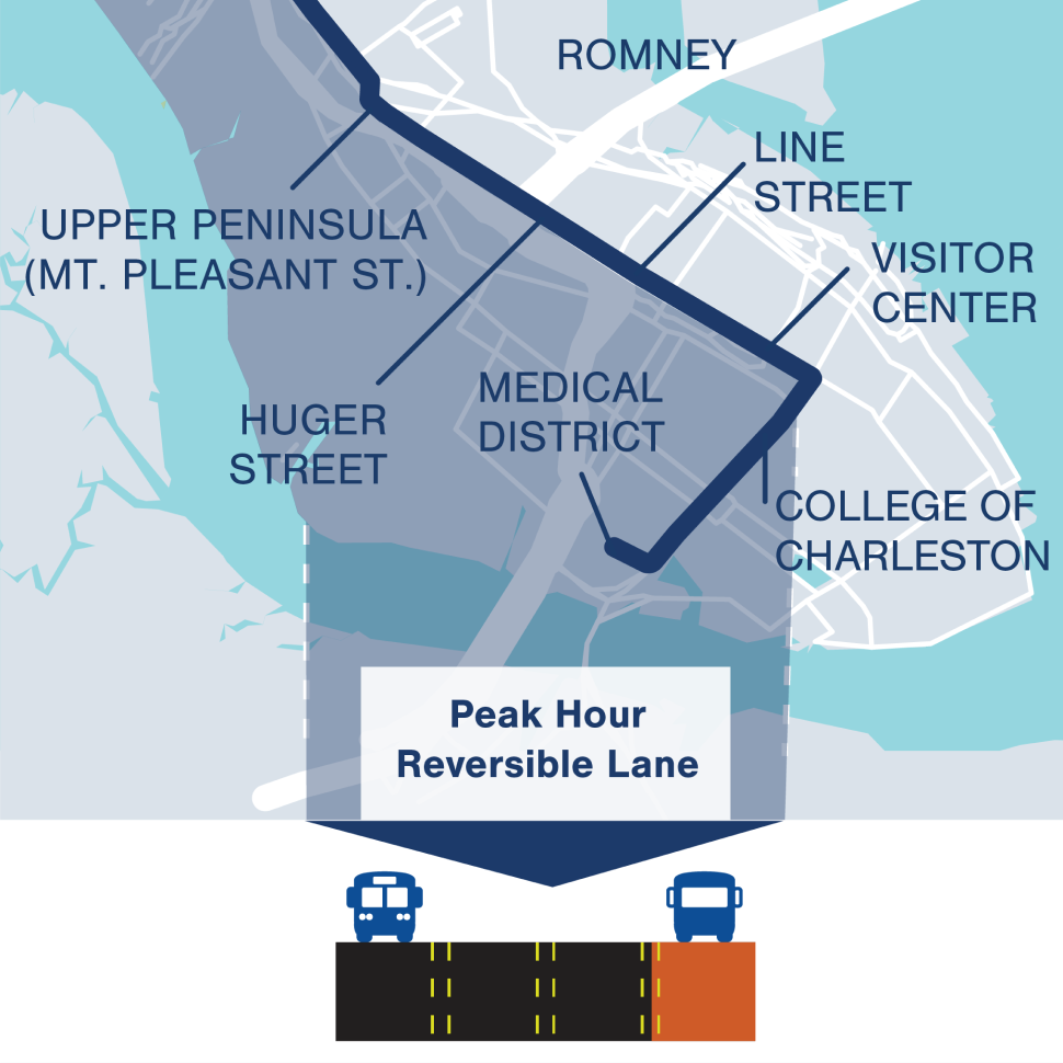
Meeting Street/Calhoun Street
Corridor Opportunities
Higher ridership
Less bicycle and pedestrian impact
More redevelopment potential
Ample bicycle and pedestrian connections
Established fixed-route transit
Established transit market
Serves transit dependent users
Roadway Design
The image below shows the roadway design proposed for the Peninsula Area of the recommended alternative, which would operate in peak hour reversible lanes.
Station Areas
Station Areas
Station area place types were identified based on public input at December workshops and stakeholder interviews and meetings over the past few months. The station areas will be further refined and some will be removed or shifted based on public and stakeholder input. 23 stations are recommended for optimal BRT operation. Click the button below to explore the interactive map and learn more about the proposed station areas.
Click on a station area to view its location and proposed place type. Please note that this list of station areas is not final and will be further refined.
Downtown Summerville
Station Area Place Type: Town Center
Town Center station areas will encourage infill and redevelopment to support a balance of jobs and housing with characteristics like traditional “Main Street” areas. These are centers of commercial and civic activity with shops, restaurants, local businesses and civic and public institutions. These areas are denser than neighborhoods and block sizes are slightly larger. Buildings near the station areas will be between 4 and 8 stories in height.
Berlin Myers Parkway
Station Area Place Type: Neighborhood
Neighborhood station areas will encourage infill and support redevelopment to include mostly residential uses as well as schools, religious gathering places, civic spaces and neighborhood-scale businesses. Block sizes will be small and buildings around the station will generally be 2 to 4 stories in height. These station areas will be the lowest density station areas along the corridor and include key characteristics such as compact development, walkable streets and a mixture of uses.
Lincolnville
Station Area Place Type: Neighborhood
Neighborhood station areas will encourage infill and support redevelopment to include mostly residential uses as well as schools, religious gathering places, civic spaces and neighborhood-scale businesses. Block sizes will be small and buildings around the station will generally be 2 to 4 stories in height. These station areas will be the lowest density station areas along the corridor and include key characteristics such as compact development, walkable streets and a mixture of uses.
College Park
Station Area Place Type: Town Center
Town Center station areas will encourage infill and redevelopment to support a balance of jobs and housing with characteristics like traditional “Main Street” areas. These are centers of commercial and civic activity with shops, restaurants, local businesses and civic and public institutions. These areas are denser than neighborhoods and block sizes are slightly larger. Buildings near the station areas will be between 4 and 8 stories in height.
Trident Health
Station Area Place Type: Employment Hub
Employment Hub station areas are those locations where there will be an emphasis on clustering of jobs, this means traditional office buildings, warehouses and light industrial uses. Block sizes are slightly larger, but the densities are higher with building heights at 6 to 10 stories. There are some residential units in these areas, but a small percentage compared to other place types.
Otranto Road
Station Area Place Type: NeighborhoodNeighborhood station areas will encourage infill and support redevelopment to include mostly residential uses as well as schools, religious gathering places, civic spaces and neighborhood-scale businesses. Block sizes will be small and buildings around the station will generally be 2 to 4 stories in height. These station areas will be the lowest density station areas along the corridor and include key characteristics such as compact development, walkable streets and a mixture of uses.
Trident Technical College
Station Area Place Type: Employment Hub
Employment Hub station areas are those locations where there will be an emphasis on clustering of jobs, this means traditional office buildings, warehouses and light industrial uses. Block sizes are slightly larger, but the densities are higher with building heights at 6 to 10 stories. There are some residential units in these areas, but a small percentage compared to other place types.
Remount Road
Station Area Place Type: Employment Hub
Employment Hub station areas are those locations where there will be an emphasis on clustering of jobs, this means traditional office buildings, warehouses and light industrial uses. Block sizes are slightly larger, but the densities are higher with building heights at 6 to 10 stories. There are some residential units in these areas, but a small percentage compared to other place types.
Station Area Place Type: North Charleston/Mall Drive
Station Area Place Type: Town Center
Town Center station areas will encourage infill and redevelopment to support a balance of jobs and housing with characteristics like traditional “Main Street” areas. These are centers of commercial and civic activity with shops, restaurants, local businesses and civic and public institutions. These areas are denser than neighborhoods and block sizes are slightly larger. Buildings near the station areas will be between 4 and 8 stories in height.
North Charleston/Mall Drive
Station Area Place Type: Town Center
Town Center station areas will encourage infill and redevelopment to support a balance of jobs and housing with characteristics like traditional “Main Street” areas. These are centers of commercial and civic activity with shops, restaurants, local businesses and civic and public institutions. These areas are denser than neighborhoods and block sizes are slightly larger. Buildings near the station areas will be between 4 and 8 stories in height.
Rivers Avenue & Reynolds Avenue
Station Area Place Type: Town Center
Town Center station areas will encourage infill and redevelopment to support a balance of jobs and housing with characteristics like traditional “Main Street” areas. These are centers of commercial and civic activity with shops, restaurants, local businesses and civic and public institutions. These areas are denser than neighborhoods and block sizes are slightly larger. Buildings near the station areas will be between 4 and 8 stories in height.
Calhoun Street & King Street
Station Area Place Type: Downtown Employment Hub
Downtown Employment Hub station areas will be the highest density station areas. Characteristics include a high concentration of jobs in offices, institutions, healthcare, retail and hospitality. Some high density residential areas will be located nearby. These areas have smaller block sizes with building heights at 10 stories or higher.
Medical District
Station Area Place Type: Downtown Employment Hub
Downtown Employment Hub station areas will be the highest density station areas. Characteristics include a high concentration of jobs in offices, institutions, healthcare, retail and hospitality. Some high density residential areas will be located nearby. These areas have smaller block sizes with building heights at 10 stories or higher.
Meeting Street & Mary Street
Station Area Place Type: Downtown NeighborhoodDowntown Neighborhood station areas will be predominantly residential in character with a mix of housing, including high density single family homes, townhouses, multi-family apartments and condos. Characteristics include nearby non-residential neighborhood amenities such as shopping, restaurants, civic spaces, parks, local businesses and other employment-based uses. Buildings will be 2 to 6 stories in height.
Shipwatch Square
Station Area Place Type: Downtown Neighborhood
Downtown Neighborhood station areas will be predominantly residential in character with a mix of housing, including high density single family homes, townhouses, multi-family apartments and condos. Characteristics include nearby non-residential neighborhood amenities such as shopping, restaurants, civic spaces, parks, local businesses and other employment-based uses. Buildings will be 2 to 6 stories in height.
Stromboli Avenue
Station Area Place Type: Neighborhood
Neighborhood station areas will encourage infill and support redevelopment to include mostly residential uses as well as schools, religious gathering places, civic spaces and neighborhood-scale businesses. Block sizes will be small and buildings around the station will generally be 2 to 4 stories in height. These station areas will be the lowest density station areas along the corridor and include key characteristics such as compact development, walkable streets and a mixture of uses.
Upper Peninsula (Mt. Pleasant Street)
Station Area Place Type: Employment Hub
Employment Hub station areas are those locations where there will be an emphasis on clustering of jobs, this means traditional office buildings, warehouses and light industrial uses. Block sizes are slightly larger, but the densities are higher with building heights at 6 to 10 stories. There are some residential units in these areas, but a small percentage compared to other place types.
Meeting Street & Romney Street
Station Area Place Type: Downtown Employment Hub
Downtown Employment Hub station areas will be the highest density station areas. Characteristics include a high concentration of jobs in offices, institutions, healthcare, retail and hospitality. Some high density residential areas will be located nearby. These areas have smaller block sizes with building heights at 10 stories or higher.
Meeting Street & Huger Street
Station Area Place Type: Downtown Employment Hub
Downtown Employment Hub station areas will be the highest density station areas. Characteristics include a high concentration of jobs in offices, institutions, healthcare, retail and hospitality. Some high density residential areas will be located nearby. These areas have smaller block sizes with building heights at 10 stories or higher.
Northwoods Mall
Station Area Place Type: Town Center
Town Center station areas will encourage infill and redevelopment to support a balance of jobs and housing with characteristics like traditional “Main Street” areas. These are centers of commercial and civic activity with shops, restaurants, local businesses and civic and public institutions. These areas are denser than neighborhoods and block sizes are slightly larger. Buildings near the station areas will be between 4 and 8 stories in height.
US 78 & Owens Drive
Station Area Place Type: Neighborhood
Neighborhood station areas will encourage infill and support redevelopment to include mostly residential uses as well as schools, religious gathering places, civic spaces and neighborhood-scale businesses. Block sizes will be small and buildings around the station will generally be 2 to 4 stories in height. These station areas will be the lowest density station areas along the corridor and include key characteristics such as compact development, walkable streets and a mixture of uses.
US 78 & I-26
Station Area Place Type: Employment Hub
Employment Hub station areas are those locations where there will be an emphasis on clustering of jobs, this means traditional office buildings, warehouses and light industrial uses. Block sizes are slightly larger, but the densities are higher with building heights at 6 to 10 stories. There are some residential units in these areas, but a small percentage compared to other place types.
Hanahan Road
Station Area Place Type: Town Center
Town Center station areas will encourage infill and redevelopment to support a balance of jobs and housing with characteristics like traditional “Main Street” areas. These are centers of commercial and civic activity with shops, restaurants, local businesses and civic and public institutions. These areas are denser than neighborhoods and block sizes are slightly larger. Buildings near the station areas will be between 4 and 8 stories in height.
Aviation Avenue
Station Area Place Type: Employment Hub
Employment Hub station areas are those locations where there will be an emphasis on clustering of jobs, this means traditional office buildings, warehouses and light industrial uses. Block sizes are slightly larger, but the densities are higher with building heights at 6 to 10 stories. There are some residential units in these areas, but a small percentage compared to other place types.
Durant Avenue
Station Area Place Type: Town Center
Town Center station areas will encourage infill and redevelopment to support a balance of jobs and housing with characteristics like traditional “Main Street” areas. These are centers of commercial and civic activity with shops, restaurants, local businesses and civic and public institutions. These areas are denser than neighborhoods and block sizes are slightly larger. Buildings near the station areas will be between 4 and 8 stories in height.
Hackemann Avenue
Station Area Place Type: NeighborhoodNeighborhood station areas will encourage infill and support redevelopment to include mostly residential uses as well as schools, religious gathering places, civic spaces and neighborhood-scale businesses. Block sizes will be small and buildings around the station will generally be 2 to 4 stories in height. These station areas will be the lowest density station areas along the corridor and include key characteristics such as compact development, walkable streets and a mixture of uses.
Pacific Box & Crate
Station Area Place Type: Neighborhood
Neighborhood station areas will encourage infill and support redevelopment to include mostly residential uses as well as schools, religious gathering places, civic spaces and neighborhood-scale businesses. Block sizes will be small and buildings around the station will generally be 2 to 4 stories in height. These station areas will be the lowest density station areas along the corridor and include key characteristics such as compact development, walkable streets and a mixture of uses.